Trip Stats
Some random statistics about my recent road trip across Canada. All numbers are approximate, and include the June begin/end trip to Vancouver Island.
Duration: 57 days.
Distance driven: 10,600 miles or 17,000 km.
Degrees of latitude crossed: 9° 5′ 22″
Degrees of longitude crossed: 63° 15′ 57″
Flat tires: 0!
Breakdowns: 0!
Illnesses: 0!
Change in driver mass: -12 lbs.
Photos taken manually: 10,000
Photos taken automatically (by dash-cam for a timelapse movie): 358,000
Times I had to stop and change the memory card in my dash-cam: 199
Total data produced: 680GB
Expense breakdown:
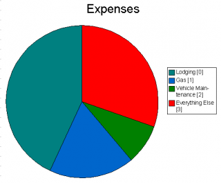
[0] The lodging figure does not include the seven nights I stayed with relatives, which would have added about another thousand dollars if it had been in hotels.
[1] Since octane ratings were downgraded last year, the Slaywagon doesn’t like regular gas much anymore, so I was buying midgrade on average.
[2] Although there were no breakdowns, I did get new brake pads, two oil changes and other preventative maintenance.
[3] “Everything Else” includes food, fares, admission charges, souvenirs and other incidental expenses. Food and souvenirs would have been the majority of it.
The total cost of the trip was about $14,000, which is both more and less than I expected. It was less in that I seemed to be spending money less quickly than I expected during the trip; most things were cheaper than I had figured. It’s more in that the total, when everything is accounted for, is larger than my most pessimistic pre-trip estimate. Shows how good I am at monitoring my spending. (Edit: I’m not confident that figure is right; mentally I can only account for about $11,000; maybe I punched something in wrong when adding things up.)
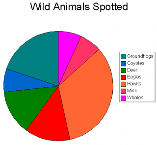
Live animals sighted (not including common birds and many dozens of snakes seen in a small area of Manitoba) (for reference, that’s one whale):
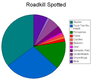
Roadkill sighted (not counting many dozens of 2D snakes spotted in a small area of Manitoba) (for reference, that’s one deer):
And here’s the overall GPS track for the whole thing. Green is eastbound, blue is westbound. The map plugin for WordPress can’t seem to handle this gracefully due to the amount of data, so here’s a link to the Google Earth file.
Home!
2011/10/01
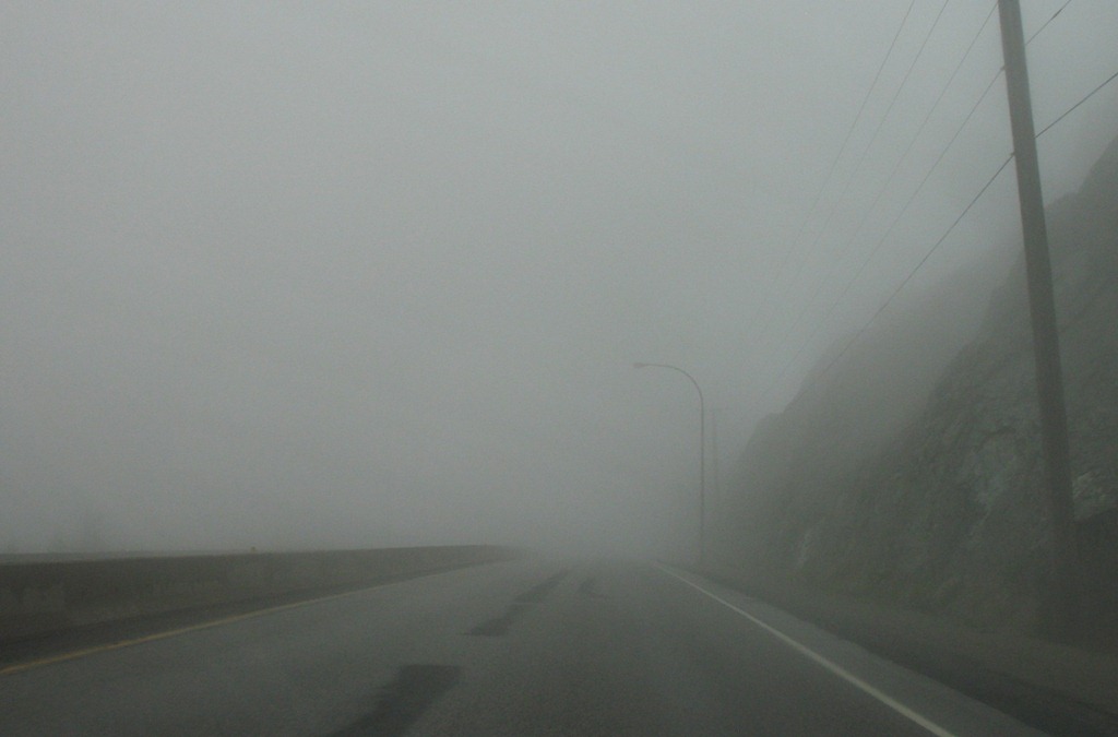
Drove from Sicamous to Vancouver today, taking alternate routes via Kelowna and the back way from Hope just for variety.
Lousy weather today – heavy rain most of the way, some very dark clouds near Hope, and driving through the clouds themselves much of the way:
Not a whole lot to say. I’m home, my physical trip is finished. (The conceptual trip, of course, finishes where it started, but I’ve already done that part.)
I was away from home for 54 days total. I’ll post some statistics about the trip in a week or so once I have all the numbers.
As for summarizing feelings – I’ll have to think about it for a while, but I’m really glad I did this. Most importantly, I put some old ghosts to rest (like my memories of the farm in Manitoba) and formed some adult impressions of the eastern provinces to supplement my vague childhood memories.
Thanks to everyone who supported me along the way!
[gmap file=”__UPLOAD__/2011/10/20111001.kml” center=”files” zoom=”auto” visible=”true” type=”satellite”]